Table of Contents
Belledonne 2021
Projet Belladonna | Du 23/08/2021 au 28/08/2021 (6 jours)
operating instructions
Various functions are available as part of the map.
mouse/touch operation
- moving by grabbing the map with a mouse-click you can move the map around
- overview map using the < button in the bottom right of the map you can expand an overview map
- zooming in and out using the + and - buttons in the top left of the map you can obtain more or less detail in the map
- switching themes or maps clicking on the ≡ icon on the right-hand side of the map you can view and select available maps and themes
- retrieving information the map may contain elements that contain more information, by clicking these a popup will show this information
- fullscreen display using the ⛶ button the map can be maximized to fullscreen display, use the ▢ button to return to page display.
keyboard operation
Keyboard operation becomes available after activating the map using the tab key (the map will show a focus indicator ring).
- moving using the arrow keys you can move the map
- overview map using the + button in the bottom right of the map you can expand an overview map
- zooming in and out using the + and - buttons in the top left of the map or by using the + and - keys you can obtain more or less detail in the map
- switching themes or maps clicking on the ≡ icon on the right-hand side of the map you can view and select available maps and themes
- retrieving information the map may contain elements that contain more information, using the i key you can activate a cursor that may be moved using the arrow keys, pressing the enter will execute an information retrieval. press the i or the escape key to return to navigation mode
- fullscreen display using the ⛶ button the map can be maximized to fullscreen display, use the ▢ button to return to page display.
It's possible that some of the functions or buttons describe above have been disabled by the page author or the administrator
Intro
Traverser Belledonne de part en part. Franchir une montagne de bout en bout, et tracer sur la carte une ligne droite que je peux presque voir de chez moi. Presque toucher du doigt. Je l'avais imaginé de nombreuses fois. Pas tant pour les paysages, puisqu'ils me sont familiers depuis toujours, que pour le défi. J'ai été servi.
Aiguebelle, Vizille. 120 kilomètres en 6 jours. Un parcours dense et cassant, sans temps mort. Je ne sais pas combien de litres de sueur j'y ai laissé, ni combien de pas j'ai dû faire pour en venir à bout. Mais l'avoir fait me laisse la douce impression du devoir accompli.
Le reportage photo n'est pas fou. Je pourrais invoquer les innombrables forêts et multiples nappes de brouillard pour expliquer cela. Ce ne serait pas complètement faux. Mais, si je suis honnête, la véritable raison est que j'étais tellement dans l'action, que j'en ai très souvent oublié la contemplation…
Parcours
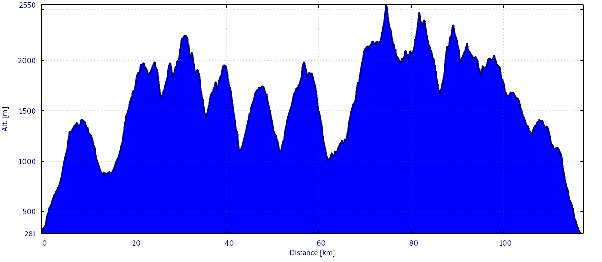
Le parcours en image et en chiffres :
- À peu près 120 kilomètres
- Entre 9 500 (selon la police) et 10 000 mètres (selon les organisateurs) de dénivelé dans un sens et dans l'autre
- 6 étapes
- 17 kilos sur le dos et 3 sur le ventre
J0 - Prologue
22/08/2021 | Alpe d'Huez - Bourg d'Oisans - Grenoble
- Le bus pour Bourg d'Oisans est à l'heure
- Comme d'habitude, le chauffeur a la flemme de faire le tour du parking
- Il se pose donc n'importe comment de l'autre côté de la rue
- Je traverse à la hâte
- A peine le temps de jeter le sac dans la soute et de monter à bord, et il part
- Il faudra se contenter d'un au-revoir furtif à travers la vitre
- Pas génial
- La correspondance avec l'express pour la gare est parfaite
- Une heure plus tard, me voilà à bon port
- Grenoble
- La ville, les gens, le bruit
- Mon frère va m'héberger pour la nuit
- Un bon plat de pâtes et du jambon cru du sud-ouest
- Au lit !

J1 - L'échauffement
23/08/2021 | Grenoble - Aiguebelle - Côte du Suet - Les Granges - La baraque à Michel - Col du Champet
- J'avais oublié les joies des nuits estivales à Grenoble
- Cette atmosphère étouffante de four à sole (et encore, c'était loin d'être la canicule)
- Les moustiques qui te bouffent des pieds à la tête et qui (pour une raison inexplicable) semblent toujours vouloir aller voir ce qui se passe dans tes oreilles
- Et, au petit jour, comme toujours, quand tu commences enfin à respirer, ce réveil qui te ramène à la réalité
- Alors, bien dormi ???
- Mes gestes sont gauches et engourdis
- Note pour mon frère : si tu trouves des céréales un peu partout dans la cuisine et dans la salon, c'est normal ; il est possible que la boîte m'ait échappé des mains
- 6h20 : c'est la traditionnelle photo du conditionnement des pieds
- … Tout le monde aime voir mes pieds…
- 6h45 : avec 15 minutes d'avance, mon oncle est là
- Mais comme j'avais prévu qu'il aurait de l'avance, je suis déjà prêt
- Il va m'emmener jusqu'à Aiguebelle
- La voiture, c'est plus rapide que le train… surtout que, la dernière fois, le train n'est jamais passé
- 7h35 : Aiguebelle
- La route est à moi sous un ciel clair
- Il fait bon pour marcher
- C'est parti !
- Les automatismes reviennent vite
- Marcher, boire, faire une pause, boire, manger une pâte de fruits…
- A force de montées, de descentes, de forêts et de sentiers, je suis déjà au Pontet
- Lorsque j'avais préparé le parcours, j'avais longuement hésité sur cette première journée
- Entre une étape raisonnable qui s'arrête au Pontet, et une étape casse-patte à plus de 2000 mètres de dénivelé qui monte jusqu'au col du Champet, j'avais finalement opté pour la première option
- Je m'étais dit que cela ferait un bon échauffement avant d'entrer dans le vif du sujet le lendemain
- Une fois sur le terrain, me voici un peu moins raisonnable
- Arrivé au Pontet, il est tôt, et l'endroit ne me fait pas rêver
- Je choisis d'aller jusqu'au col du Champet, en passant par la baraque à Michel
- Mieux vaut avoir un peu d'avance qu'un peu de retard
- Je ne sais pas qui est ce Michel, mais arriver jusqu'à sa baraque m'a semblé interminable
- Seul dans l'ombre de la forêt (j'aime pas la forêt), je transpire des tonneaux et perds des litres d'eau
- Le dernier relai me semble interminable
- Mon sac ne peut pas être plus lourd qu'à cet instant
- Il me cisaille les épaules et me meurtrit le bas du dos
- Je n'en vois pas la fin
- Après m'être arrêté à peu près tous les 15 mètres dans le dernier kilomètre, j'entrevois enfin la fin du calvaire
- Le col du Champet
- Pas besoin de chercher bien longtemps l'endroit de mon premier bivouac
- Juste là, un plateau herbeux face au couchant, qui domine toute la vallée
- J'ai 20 kilomètres et environ 2100 mètres de dénivelé dans les pattes
- Aucun doute : je suis bien échauffé


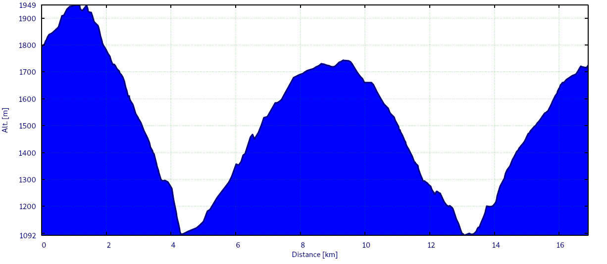
Le profil de l'étape :
- Distance approximative : 20 km
- Dénivelés approximatifs : 2100 D+ / 740 D-
- Durée de l'étape : 6h42
J2 - Le jour d'après
24/08/2021 | Col du Champet - Le Grand Chat - Refuge de la Perrière - Col d'Arpingon - Refuge des Férices - Chalet de Pré nouveau - Refuge de Claran
- 7h17
- J'ai oublié de mettre le réveil
- Un peu d'air, ciel clair au-dessus d'une mer de nuages. On supporte bien le pantalon. Pâtes bolo pour démarrer la journée…
- L'étape commence par un chemin roulant sur la ligne de crêtes
- C'est beau
- J'ai les jambes un peu lourdes, mais pas autant qu'on aurait pu le craindre après l'étape de la veille
- Sous le col de la Perche, des marmottes pas farouches me regardent passer l'air circonspect
- Je dois déjà avoir un air animal
- La montée du col d'Arpingon est dure à encaisser
- J'ai froid, et les jambes ont un peu de mal à suivre le rythme
- Après une bonne descente à flan de montagne, le refuge des Férices se dresse enfin
- L'endroit est magnifique
- J'avais prévu de dormir là, mais il faut se rendre à l'évidence : le terrain ne se prête guère au bivouac
- Je décide donc de pousser jusqu'au refuge de Claran, même si cela rallonge considérablement l'étape
- La forêt et le brouillard me tendent les bras
- L'humidité grimpe
- On ne voit pas à 10 mètres
- La pluie menace
- Comme la veille, la dernière montée est une calamité
- J'ai déjà dépassé d'une heure l'heure après laquelle je m'étais promis de ne plus marcher pour avoir un temps de repos suffisant
- Mais pas trop le choix : il n'est pas possible de camper là où je suis
- Je garde la foi
- Et le refuge finit enfin par arriver
- Montage express de la tente
- Truffade auvergnate pour me réchauffer et me remonter le moral
- A peine couché, la pluie se met à tomber
- Elle ne cessera qu'au petit jour


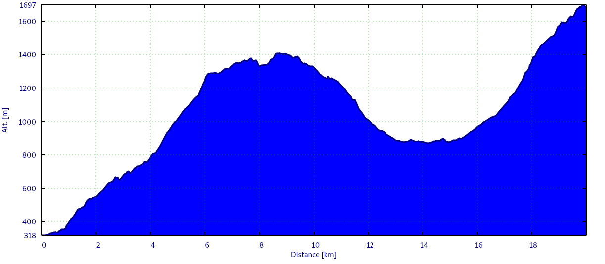
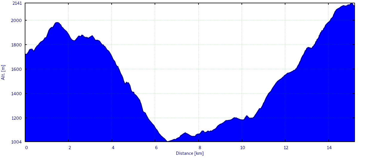
Le profil de l'étape :
- Distance approximative : 19 km
- Dénivelés approximatifs : 1800 D+ / 1700 D-
- Durée de l'étape : 8h39
J3 - Itinéraires bis
25/08/2021 | Refuge de Claran - Refuge de la Pierre du Carré - Pont Haut - Le Praillet - Le Cohard - Chalet du Bout - Lac du Léat
- 6h32 : je suis réveillé par des gens qui pensent que tout le monde l'est parce qu'eux le sont
- J'adore
- Le ciel est enfin clair après une nuit pluvieuse
- Tout est humide et à l'ombre, il fait frais et j'ai faim
- Le soleil finit par sortir enfin
- Je me mets en route, cap sur le lac du Léat
- Arrivé au refuge de la Pierre du Carré, Bison Futé me signale des travaux forestier sur le sentier du Plan de l'Ours
- Il va falloir prendre un itinéraire bis
- C'est plutôt simple : au lieu de faire le tour de la vallée, tu la descends tout droit par la forêt
- J'aime pas la forêt
- C'est sombre, humide et il y a des toiles d'araignées
- Non, vraiment, j'aime pas la forêt, et la forêt me le rend plutôt bien
- A la dixième glissade sur l'humus mouillé, je finis les 4 fers en l'air
- Saloperie de forêt
- Et une fois au fond de la vallée, il faut la remonter dans l'autre sens
- Encore une forêt
- On ne voit rien d'autre que des arbres
- Je ne vois pas l'intérêt
- Les sous-bois et les racines qui te font trébucher continuent jusqu'au Cohard
- Le GR738 passe normalement sur la gauche, par l'Oule
- Mais il y a un chemin plus direct par le chalet du Bout, qui mène au lac du Léat, où j'ai prévu de bivouaquer
- Pourquoi faire plus long quand il y a plus court ?
- J'opte pour le chalet du bout
- L'endroit porte bien son nom
- On ne voit pas le bout de cette montée plus courte, certes, mais sacrément sèche !
- En tout cas, ça me sèche
- Et je ne suis pas fâché de voir se dessiner le lac du Léat
- L'endroit est bucolique
- Un petit plan d'eau, une cabane, un troupeau de moutons et Pote, le chien du berger, qui n'en fait qu'à sa tête
- Je plante ma tente au milieu de ce gentil bazar
- Enfin un peu de soleil et de chaleur
- Tout ce qui était encore mouillé de la veille va enfin pouvoir sécher
- Au menu ce soir, colombo de poulet
- C'est un peu sec et ça manque de saveur
- Par contre, ça colmate la faim (et sans doute aussi tout ce qui aurait besoin d'être colmaté)


Le profil de l'étape :
- Distance approximative : 17 km
- Dénivelés approximatifs : 1470 D+ / 1540 D-
- Durée de l'étape : 6h44
J4 - La moitié du chemin
26/08/2021 | Lac du Léat - Montagne de Tigneux - Pont de la Valloire - Les 2 Ruisseaux - Lacs des 7 Laux
- Temps clair, petite brise, il fait frais et humide
- J'opte pour le poulet tikka au petit déjeuner
- Ah, là, ça ne manque pas de saveur ! J'ai l'impression d'avoir pris un coup de soleil buccal…
- On se gèle les pinceaux, mais heureusement le chemin grimpe vite vers la montagne de Tigneux
- Ça réchauffe
- Arrivé à la Grande Valloire, le soleil passe enfin au-dessus des montagnes
- J'ai trouvé la maison de mes rêves
- Un petit bout de chalet posé sur un promontoire au bout d'une vallée isolée
- Un panneau solaire, une douche solaire, pas de voisin à moins de 10 kilomètres
- Le paradis !
- Le chemin replonge ensuite dans la forêt vers le Fond de France
- Je suis à mi-parcours, et tout va bien !
- Je décide de terminer l'étape aux lacs des 7 Laux
- A mi-montée, les 2 ruisseaux
- Je suis déjà passé par cet endroit au moins 10 fois, et à chaque fois je me perds
- Il me faut toujours un quart d'heure de tournage en rond pour retrouver le sentier
- Va y comprendre quelque chose…
- Ici, la route est nettement plus fréquentée (pour ne pas dire mal famée)
- Je me demande comment tous ces gens font pour sentir le frais, alors que moi je sens le sanglier…
- Cette question métaphysique me taraude toute la fin d'étape, mais ne m'empêche pas d'apprécier l'arrivée à côté du refuge des 7 Laux
- J'ai une faim de loup
- Je rêve d'un gratin de pommes de terre (avec plein de crème fraîche) cuit au feu de bois et accompagné d'une viande en sauce
- C'est le moment idéal pour sortir l'arme absolue
- Fondue 4 fromages avec croûtons
- Je suis assis sur un caillou, et j'attends de savoir qui, de la montagne ou du brouillard, aura raison en premier du soleil qui est en train de se coucher
- Brouillard 1, montagne 0
- Franchement, si j'avais eu un deuxième sachet de fondue sous la main, il aurait pris le même chemin que le premier
- … Mes rations sont manifestement un peu trop légères !


Le profil de l'étape :
- Distance approximative : 15 km
- Dénivelés approximatifs : 1600 D+ / 1200 D-
- Durée de l'étape : 7h12
J5 - Enfin des cailloux
27/08/2021 | Lacs des 7 Laux - Col des 7 Laux - Col de la Vache - Pas de la Coche - Brèche de Roche Fendue - Col de la Mine de Fer - Refuge Jean Collet - Passerelle du Mousset
- Pas la plus grande dans les chiffres, mais la plus intense et la plus spectaculaire des étapes
- On quitte enfin la forêt du Nord pour les pierriers du Sud
- Départ sous le soleil
- Porté par l’allégresse matinale, j'ai bien failli faire fausse route et me retrouver au Rivier d'Allemont
- Heureusement, je m'en suis rendu compte à temps
- Trajectoire corrigée, voici le moment de mon premier face à face avec un patou pas content
- J'ai fait comme on m'a dit
- Pas bouger
- Le laisser approcher
- Lui parler calmement
- Et quand il a senti que je sentais plein de choses sauf le loup affamé, il est parti
- Pourquoi donc avoir appelé cela le col de la Vache ?
- A force d'escalade dans les blocs plus gros que moi, une évidence s'est imposée : je ne vois pas bien quelle vache pourrait monter là-haut…
- J'en ai donc déduis que c'était simplement de l'humour vache : “Oh, la vache ! Tu vas en chier pour aller au sommet !”
- La descente, à peine plus simple, me conduit sur la route du Pas de la Coche
- Le vent se lève et charrie des flots de nuages à travers la passe étroite
- Le soleil n'est même plus assez chaud : obligé d'enfiler la Gore-Tex
- Juste le temps de se faufiler à flan de falaise vers la deuxième grande ascension de la journée
- La brèche de Roche Fendue
- Là, pour le coup, aucun mauvais jeu de mot
- Une petite brèche au milieu de plein de gros cailloux
- C'est dur et c'est beau
- Moi, j'ai trouvé le moyen de me prendre une gamelle dans le seul endroit plat de la montée (3 mètres entre 2 gros rochers)
- Rien de cassé
- Arrivé au sommet, le brouillard vient se poser sur le col de la Mine de Fer
- Une ombre bouge devant moi
- Il me faudra plusieurs secondes pour comprendre qu'elle n'a rien d'humain : un bouquetin perdu me file sous le nez
- Descente dans la brume
- Une halte au refuge Jean Collet
- Ça grouille de soixantenaires qui parlent trop fort
- Et, de toute façon, il n'y a pas de place à proximité pour poser ma tente
- Fatigué par la journée, je me mets en quête d'un lieu de villégiature
- Pas facile
- Au niveau de la passerelle du Mousset, je détecte un petit bout d'herbe pas très aguichant mais à peu près plat
- Pile-poil de quoi monter la tente
- Il fait froid
- On ne voit rien
- J'ai faim
- Pas de photo ce soir


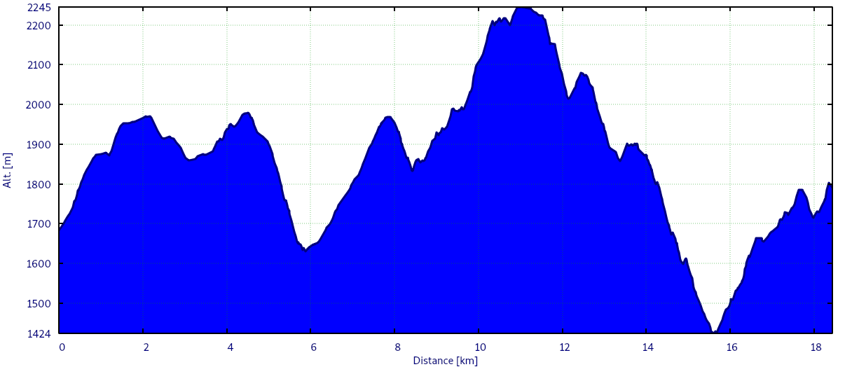
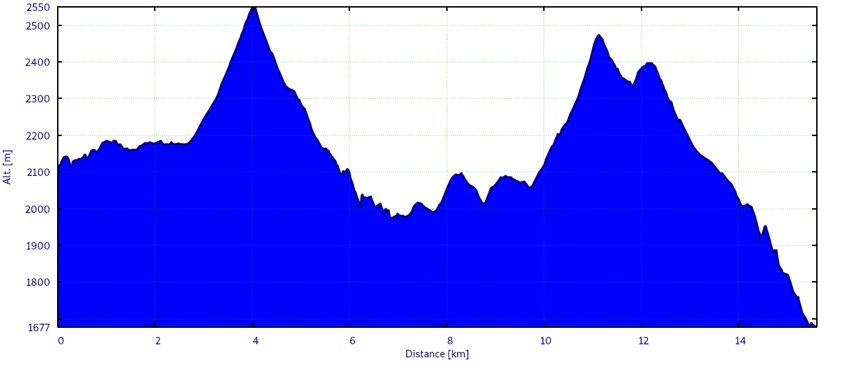
Le profil de l'étape :
- Distance approximative : 15 km
- Dénivelés approximatifs : 1280 D+ / 1720 D-
- Durée de l'étape : 8h22
J6 - Un semi-marathon et demi
27/08/2021 | Passerelle du Mousset - Col de la Sitre - Refuge de la Pra - Lacs Robert - Le Recoin de Chamrousse - Vizille
- “Ah gla gla, il fait froid. Tout est trempé, et je suis dans un trou qui ne voit probablement jamais le soleil…”
- Ainsi commencent mes notes du jour
- Le chien du berger a aboyé toute la nuit et j'ai été obligé de mettre une petite laine pour ne pas congeler
- Les premiers hectomètres dans l'ombre du ravin des Excellences me feront dire que j'avais eu du nez de poser ma tente dans cet endroit un peu ingrat
- Le spot suivant… est au lac du Crozet, 2 heures de marche plus loin
- Il y a plus sympa comme réveil que la montée du col de la Sitre
- Mais, ensuite, c'est tellement beau que ce mauvais passage est très vite oublié
- Le ciel est clair, le vent souffle un peu
- Quelques touffes d'herbe sont encore blanches de la nuit
- Au-dessus, un troupeau de chamois fait dégringoler quelques pierres
- Et puis, c'est la descente vers le lac du Crozet
- Arrivé à la Pra, enfin du plat
- Du sac à mes jambes, tout me semble étrangement léger
- J'ai l'impression grisante de voler sur le haut-plateau, au chaud, le soleil dans les yeux
- Le temps d'arriver au lac Léama
- Retour du brouillard, retour du froid, retour de la montée
- Des lacs Robert, je ne verrai que le panneau
- Descente entre cailloux et forêt vers le Recoin de Chamrousse
- J'avais prévu de m'arrêter ici, mais à quoi bon ?
- Il est tôt, j'ai encore de bonnes jambes et Vizille n'est plus si loin
- Un coup de fil à Charlotte pour adapter la logistique du retour et c'est décidé : je termine aujourd'hui plutôt que demain
- J'ai conscience d'avoir seulement à moitié conscience de ce dans quoi je me lance
- C'est déjà ça
- La fin de l'étape est une très longue errance sans grand intérêt
- J'oscille entre le mode sans cerveau quand le terrain est facile, et le mode ultra-bobo quand c'est compliqué
- Toutes les parties de mon corps piquent, brûlent et tirent en même temps
- J'ai mal partout
- Les kilomètres défilent
- La grande descente vers Vizille est un cauchemar pour mes genoux cagneux
- Mais il en faudra plus pour m'arrêter
- Enfin le dernier kilomètre
- Une dernière poignée de noix de cajou pour aller au bout
- 17h52 : Pari gagné…
- … et synchronisation parfaite : Charlotte et Éline arrivent 2 minutes après moi !
- La joie des retrouvailles
- Direction la maison
- Je crois que j'ai rarement mangé autant en un seul repas !


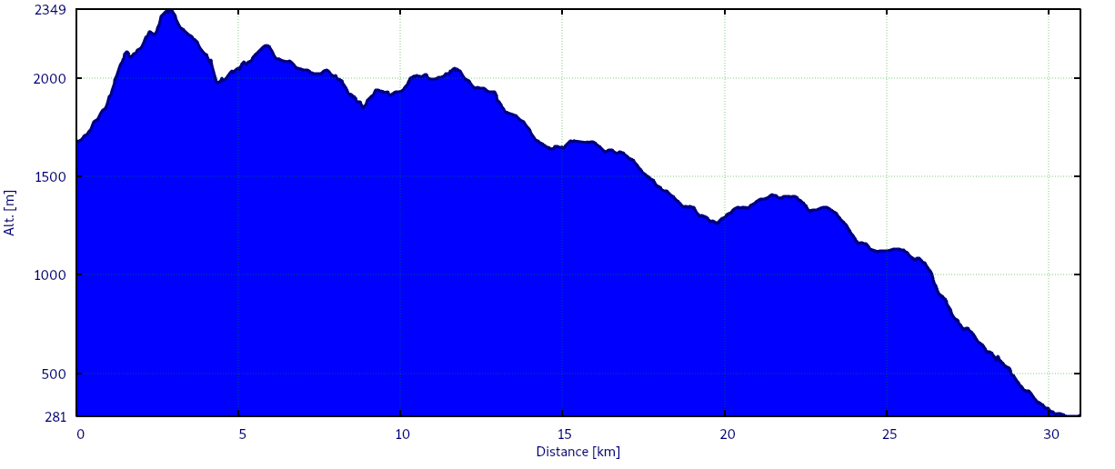
Le profil de l'étape :
- Distance approximative : 31 km
- Dénivelés approximatifs : 1610 D+ / 3020 D-
- Durée de l'étape : 9h52